Your Infrastructure Needs Smarter Visibility

Managing massive transmission corridors, substations, and telecom networks over vast remote GCC terrain means your teams face constant pressure. Traditional inspections risk crews, take days to inspect per asset and fail to detect faults until outages occur. Manual methods have a hard time keeping up with the scale of the modern infrastructure – thousands of towers scattered all across deserts, substations in harsh climates or solar farms requiring regular monitoring. Helicopter surveys cost heavily, rope-access teams move slowly, and ground inspections can’t reach everything. Meanwhile, equipment deteriorates, vegetation re-encroaches and thermal anomalies develop outside of view. You need a smarter way to see what’s happening across your entire network.

image
Safety at Height

Your field teams climb live towers and work near energized equipment, facing electrical hazards and fall risks daily.

image
Time-Intensive Inspections

Helicopter surveys and rope-access crews require days of mobilization just to cover a single transmission corridor section.

power-utlity-circle
image
Late Fault Detection

By the time you spot corrosion, hotspots, or vegetation encroachment, unplanned outages and emergency repairs are already costing you.

image
Compliance Documentation

Meeting regulatory audit requirements demands high-quality visual and thermal data that manual inspection methods struggle to produce consistently.

Our Drone Services for Power & Utilities

Specialized inspections that deliver asset intelligence without shutting down your operations.

powerline-inspection

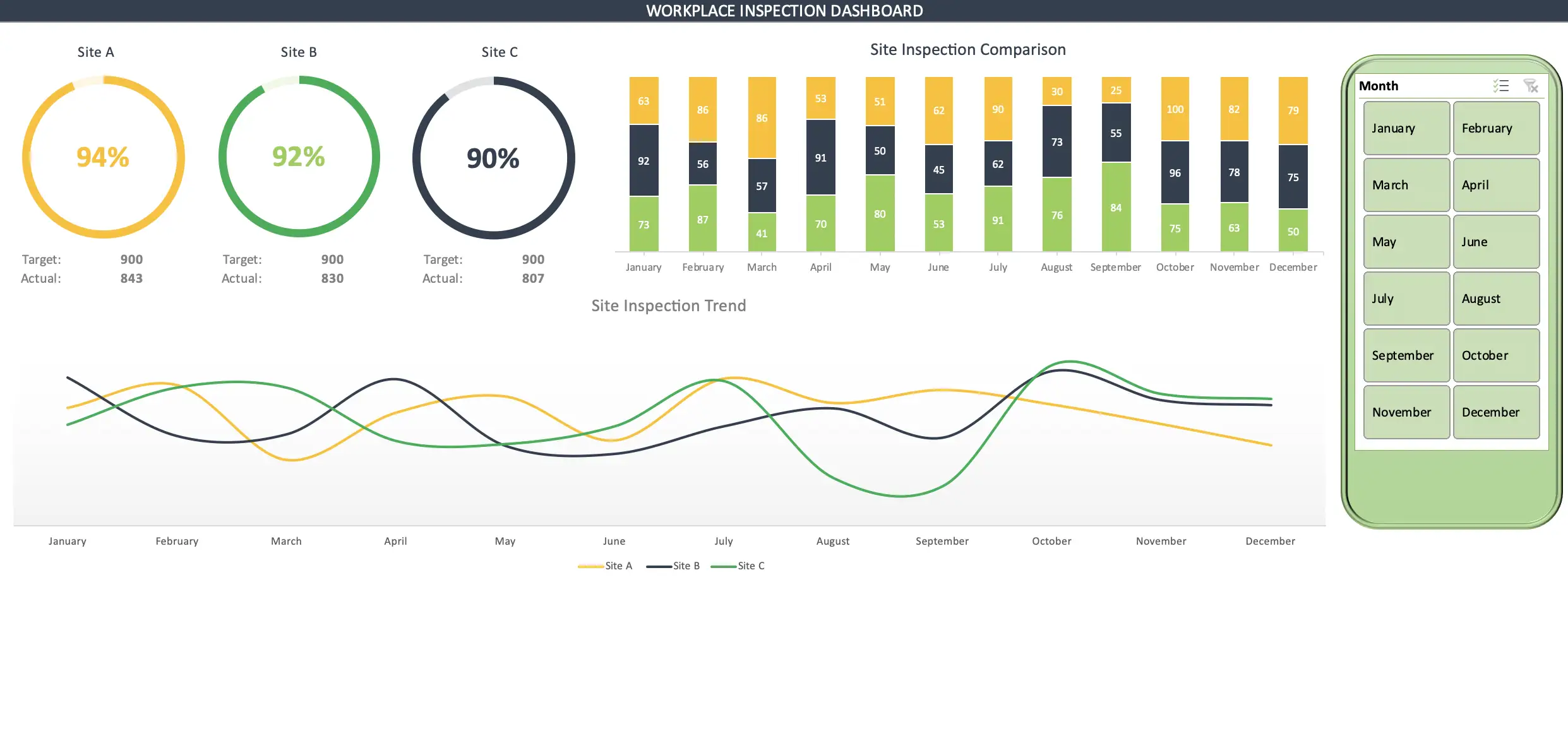
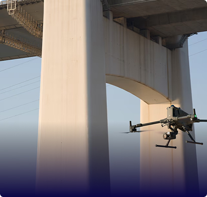
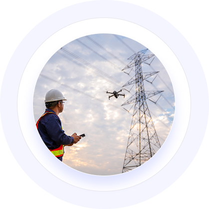
Powerline Inspection (OHPL)

We inspect your high-voltage lines while they’re energized, capturing thermal hotspots, conductor sag, insulator damage, vegetation clearance, and corona discharge without downtime.

  • Visual, thermal, LiDAR, and UV sensors capture everything
  • We detect sagging cables, damaged insulators, and partial discharge
  • Cover kilometers daily without climbing crews or helicopter costs
  • You get georeferenced fault maps that integrate into workflows
telecom-tower-inspection

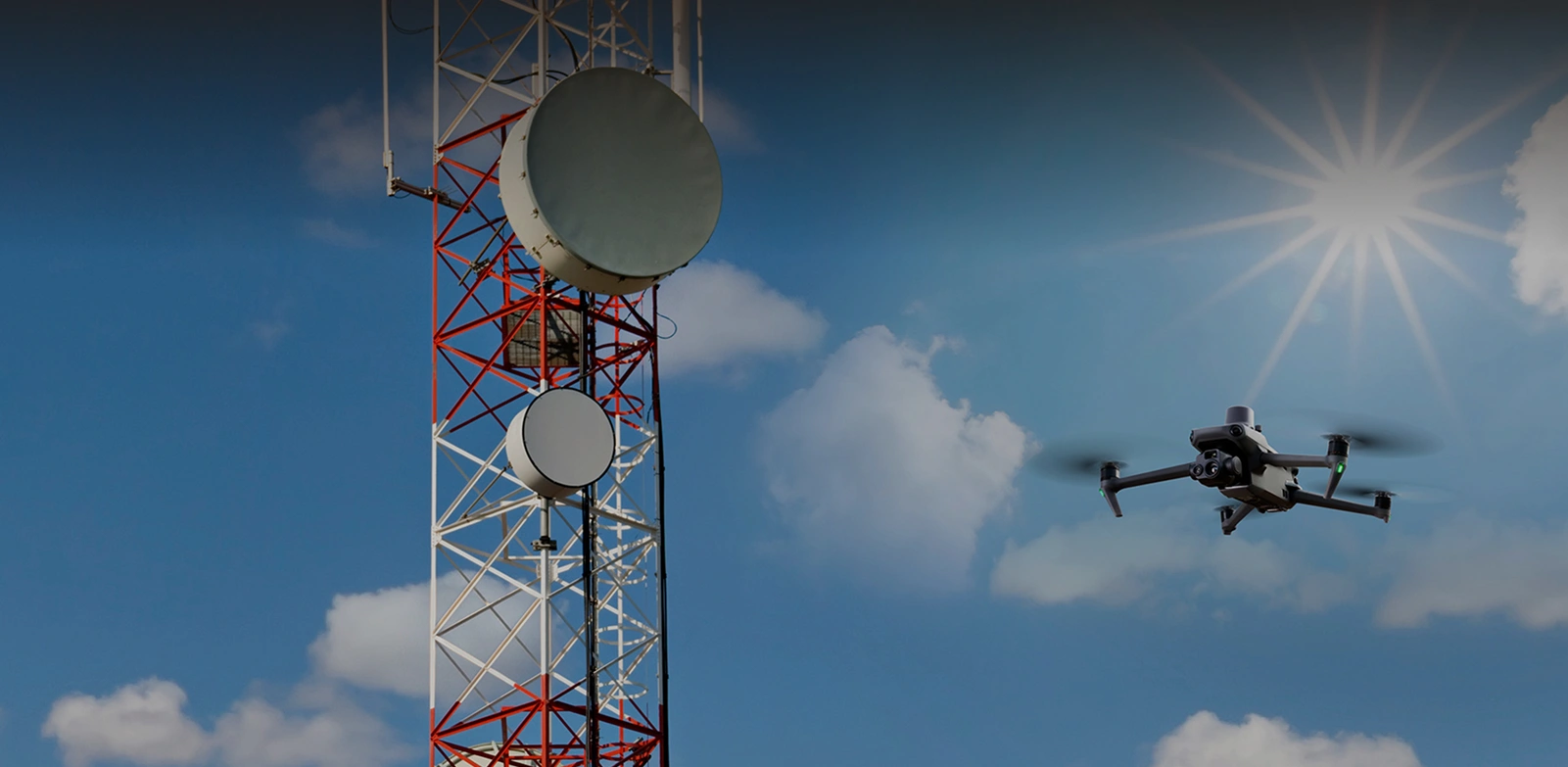
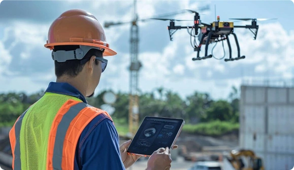
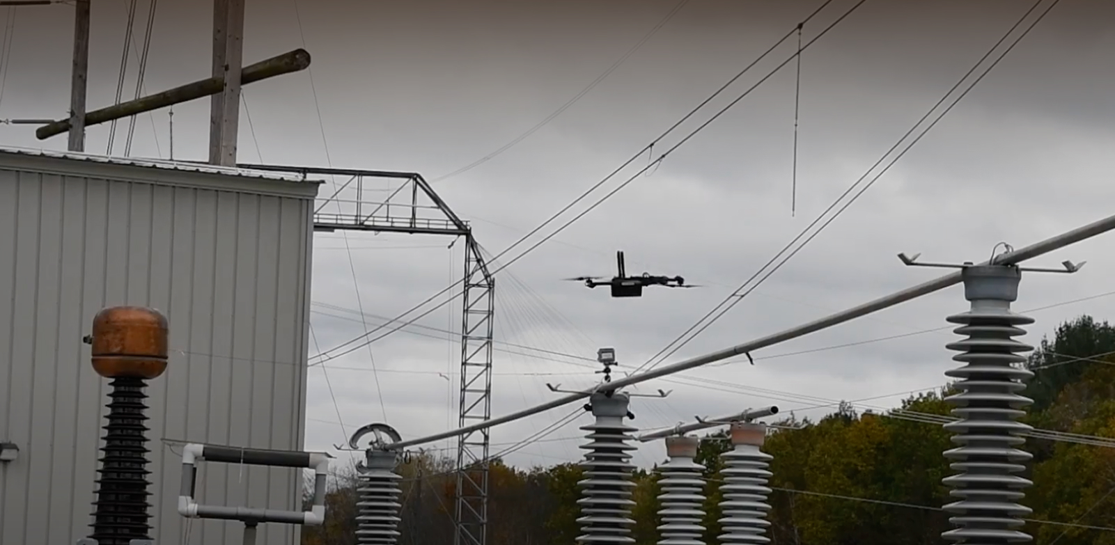
Telecom Towers Inspection

We inspect your tower faces, antennas, cabling, and structural components for 4G/5G expansion without rope-access delays or taking sites offline. 

  • Access platforms, antennas, guy-wires, and microwave links safely
  • Thermal imaging shows you overheating components and loose fasteners
  • High-definition imagery captures corrosion and lightning-strike damage early 
  • Support your rapid deployment schedules for expanding network coverage
digitaltwin-3d

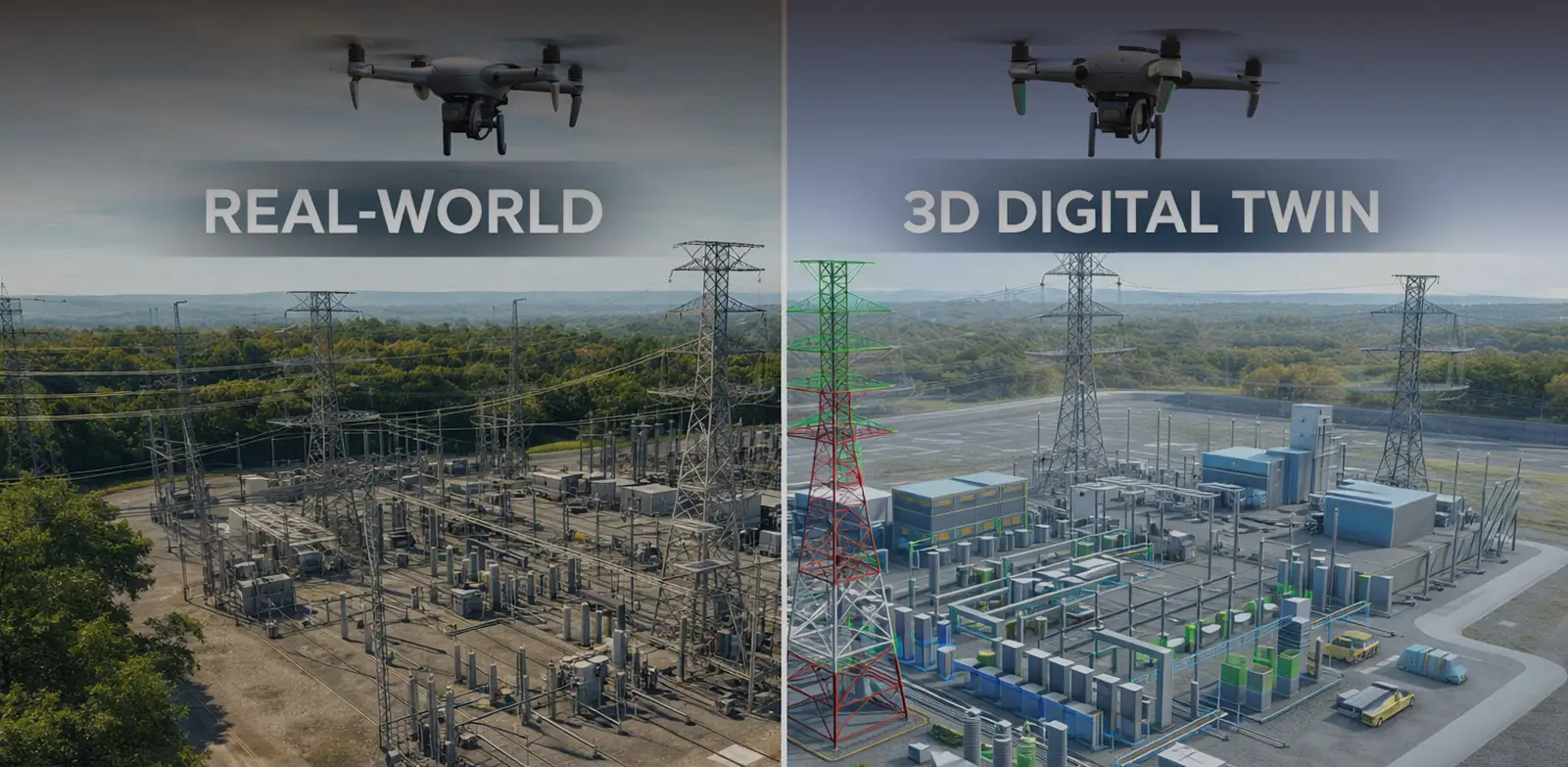
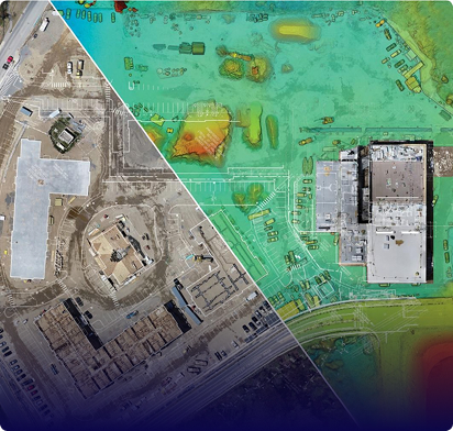
3D Digital Twin Development

We use LiDAR and photogrammetry to create precise digital replicas of your substations, corridors, and tower sites for virtual condition tracking and clearance analysis.

  • Generate survey-grade models for your asset lifecycle planning
  • Track structural changes, vegetation drift, and equipment degradation over time 
  • Enable immersive visualization for stakeholder reviews and team training  
  • Integrate with your asset management systems for predictive maintenance

Gulfnet Insight® Turns Your Inspection Data Into Action

Our cloud platform transforms raw drone captures into prioritized maintenance decisions and compliance-ready documentation you can actually use.

Our system flags anomalies across thousands of inspection images.
Array

Every fault links to precise GPS coordinates and IDs.
Array

See how your asset conditions change across inspection cycles.
Array

Export work orders directly into your enterprise systems.
Array
defect-analytics

Schedule Your Free Infrastructure Assessment - See How Drone Intelligence Can Cut Your Risk, Downtime, and Inspection Costs

Other Industries

Frequently Asked Questions

GulfNet Emirates provides comprehensive drone inspection services for power transmission lines in the UAE, covering everything from overhead high voltage corridors to remote desert infrastructure. Our fleet uses thermal imaging, LiDAR, and high resolution RGB cameras to detect conductor sag, insulator defects, corrosion, and vegetation encroachment while lines remain energized. Each mission produces georeferenced fault reports that integrate directly into your asset management workflows. Whether you need a single corridor assessed or a network wide program across the UAE, our GCAA certified pilots and enterprise grade platforms deliver the inspection data your operations team needs to act on.

Drone based inspection of high voltage power lines in Dubai involves deploying enterprise grade UAVs equipped with zoom optical cameras, thermal sensors, and LiDAR payloads to capture detailed condition data without de-energizing the network. Certified pilots fly pre-programmed routes along transmission corridors, maintaining safe electrical clearance distances at all times. The drones capture thousands of high resolution images per mission, which are then processed to identify hotspots, broken strands, damaged insulators, and clearance violations. This approach eliminates the need for climbing crews and helicopter flyovers, significantly cutting both risk and inspection turnaround time for Dubai’s power operators.

Thermal drone inspection for power grids in the Middle East uses infrared sensors to detect temperature anomalies that indicate developing faults long before they cause outages. These sensors identify overheating joints, loose connections, failing insulators, and unbalanced loads across substations and transmission lines, even in the region’s extreme ambient heat. Unlike visual inspections alone, thermal data reveals hidden electrical stress points invisible to the naked eye. GulfNet Emirates calibrates all thermal readings against environmental baselines specific to GCC climate conditions, ensuring accurate diagnostics. The resulting thermal maps are delivered with precise GPS coordinates for targeted maintenance action.

After each drone powerline inspection mission, we deliver comprehensive inspection reports, annotated imagery, thermal maps, 3D models, and CSV-style condition logs. These outputs can be formatted to be directly ingested into your CMMS, SCADA, or asset management platforms. Our power grid drone monitoring solutions also integrate through our Gulfnet Insight(R) cloud platform where you can access, analyse and export results into your existing data flow processes. We work closely with your IT and operations teams during the onboarding process to ensure seamless integration. Our goal is to make inspection data actionable within your existing systems without disrupting existing processes.

We deal with all the regulatory requirements for you. Our team liaises closely with the General Civil Aviation Authority (GCAA) and other local authorities concerned with aviation to obtain relevant permits and airspace clearances for drones for powerline inspection as well as telecom tower drone inspection operations across the UAE and wider GCC region. We are aware of and comply with all the BVLOS (Beyond Visual Line of Sight) and UAS operational regulations applicable in the region. For each project, we customize flight plans, make site-specific risk assessments and secure necessary approvals from the relevant stakeholders. Our certified pilots hold current UAE remote pilot licenses and maintain comprehensive insurance coverage, ensuring full compliance throughout every mission.

GulfNet Emirates is widely recognized as a leading drone company for utility asset inspection in the UAE, offering end to end solutions from flight planning through to actionable reporting. What sets us apart is our combination of GCAA certified pilots, enterprise grade DJI platforms, multi sensor payloads, and our proprietary Gulfnet Insight cloud platform for data analysis. We serve power authorities, telecom operators, and water utilities across the Emirates, delivering inspection programs that reduce costs, improve safety, and accelerate fault resolution. Our track record across critical GCC infrastructure projects makes us a trusted partner for utility operators seeking reliable aerial inspection.

GulfNet Emirates offers specialized drone inspections for electrical substations across the GCC, providing detailed thermal and visual assessments of transformers, bushings, switchgear, and bus bar connections. Our drones capture high resolution imagery and infrared data from angles that are difficult or dangerous for ground crews to reach, identifying hotspots and insulation degradation early. Each inspection generates a structured condition report with severity classifications and GPS tagged findings that feed directly into your maintenance planning systems. Operating from the UAE with regional coverage across Saudi Arabia, Qatar, Oman, Kuwait, and Bahrain, we bring consistent inspection quality to substations of all voltage classes.

Inspecting electrical towers safely using drones in the UAE requires GCAA certified pilots, pre-flight risk assessments, and strict adherence to electrical clearance protocols. GulfNet Emirates follows a structured safety process that includes coordination with grid operators, airspace approvals, and mission specific hazard evaluations before any drone takes flight. Our pilots maintain safe standoff distances from energized conductors while using high zoom cameras to capture detailed imagery of tower steelwork, cross arms, insulators, and foundations. This approach completely removes the need for personnel to climb towers or work at height, eliminating fall risk and electrical exposure while delivering superior inspection data.

GulfNet Emirates delivers power utilities drone services for fault detection across the GCC using a combination of thermal imaging, visual inspection, and LiDAR scanning. Our services are designed to identify issues such as overheating components, cracked insulators, conductor damage, corrosion, and vegetation encroachment before they escalate into outages. After each mission, our analytics team processes the captured data through the Gulfnet Insight platform, which flags anomalies and assigns severity ratings automatically. Fault locations are mapped with precise GPS coordinates and compiled into maintenance ready reports. This proactive detection approach helps GCC utility operators shift from reactive repairs to planned, cost effective maintenance.

Yes, GulfNet Emirates provides drone inspection for water and utility infrastructure in the UAE, covering assets such as water treatment facilities, storage tanks, pipeline corridors, pumping stations, and distribution networks. Our drones perform visual and thermal assessments to detect leaks, structural wear, corrosion, and thermal irregularities across these assets without disrupting operations. The inspection data is compiled into detailed reports with annotated imagery and condition ratings that support your maintenance scheduling. Whether you manage a municipal water network or an industrial utility facility, our aerial inspection programs offer a safer and faster alternative to manual surveys across the UAE.

Share your asset list and inspection priorities
to receive a tailored scope and plan.

Request our capabilities deck and platform walkthrough to see reporting and workflows.